
Chile
Fast Facts
Official Name: Republic of Chile
Form of Government: Republic
Capital: Santiago
Population: 17,216,945
Official Language: Spanish
Money: Chilean peso
Area: 291,932 square miles (756,102 square kilometers)
What You Should Know
Prior to the arrival of the Spanish in the 16th century, the Inca ruled northern Chile while the Mapuche inhabited central and southern Chile. Although Chile declared its independence in 1810, decisive victory over the Spanish was not achieved until 1818. In the War of the Pacific (1879-83), Chile defeated Peru and Bolivia and won its present northern regions. It was not until the 1880s that the Mapuche were brought under central government control. After a series of elected governments, the three-year-old Marxist government of Salvador ALLENDE was overthrown in 1973 by a military coup led by General Augusto PINOCHET, who ruled until a freely elected president was inaugurated in 1990. Sound economic policies, maintained consistently since the 1980s, contributed to steady growth, reduced poverty rates by over half, and helped secure the country's commitment to democratic and representative government. Chile has increasingly assumed regional and international leadership roles befitting its status as a stable, democratic nation.
Geography
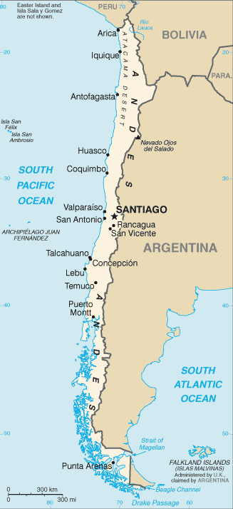
Chile is divided into three general topographic regions: the lofty Andean cordillera on the east; the low coastal mountains of the west; and the fertile central valley between. The Andes, occupying from one-third to the entire width of the country, stretch from the Puna de Atacama in the north, a high plateau with peaks averaging 4,600 m (15,000 ft), to middle Chile, where, on the border with Argentina, rises the highest peak in the Western Hemisphere, Aconcagua (6,960 m/22,834 ft), and then, diminishing in height, run south into the Chilean lake country, with its snowcapped volcanoes and several passes.
The region of the Andes is a seismically active area with low magnitude earthquakes occurring on a regular basis, even to about a dozen a month. Situated on the South American Tectonic Plate, the country has recorded over 100 major earthquakes (magnitude 7 or higher) since such record keeping began in 1570. On 13 June 2005, a 7.8 magnitude earthquake occurred in Tarapaca that was felt as far away as Santiago and Brasília, Brazil. At least 11 people died.
The coastal range, verging from 300 to 2,100 m (1,000 to 7,000 ft) in height, rises from the sea along most of the coast. In the extreme north, the coastal mountains join with the Andean spurs to form a series of plateaus separated by deep gorge like valleys. In the south, the valleys and the coastal range plunge into the sea and form a western archipelago; fjords reach into the range at about 42°S.
The central valley, an irregular alluvial plain 965 km (600 mi) long, 73 km (45 mi) wide at its maximum, and up to 1,200 m (4,000 ft) high, begins below the arid Atacama Desert of the north and ends at Puerto Montt in the south. Fertile between the Aconcagua and Bío-Bío rivers, this valley is the center of agriculture and of population. Although some 30 rivers rise in the Andes and descend to the Pacific, cascades and great waterfalls severely limit navigation; the ocean itself facilitates transportation between the different regions of this narrow country.
The northern side of the Strait of Magellan, part of Patagonia (a region shared by Chile and Argentina), and part of the island of western Tierra del Fuego (divided between Chile and Argentina) is low, glaciated, morainal country.
Climate
Climatic zones range from the subtropical deserts in the north to the temperate rain forests of Aisén and the tundras of Magallanes in the extreme south. The cold Humboldt Current, traveling northward from the Antarctic, affects the climate of the coastal regions of central and northern Chile. Generally, however, Chile is divided into three climatic regions: (1) The north, which contains the Atacama Desert, one of the driest regions in the world, is characterized by hot and arid weather in the lowlands and occasional summer showers in the Andean highlands. (2) The middle, extending about 1,450 km (900 mi) from 30–43°s, has a Mediterranean climate, with mild, wet winters, averaging 11°c (52°f), and long, dry summers, averaging 18°c (64°f). (3) The south, a region of mountains and fjords, has high winds and heavy rains. Annual rainfall ranges from no recorded precipitation in some parts of the north to 50–100 cm (20–40 in) around Concepción, in south-central Chile, to more than 406 cm (160 in) in some southern regions. South of the Bío-Bío River, rains occur all year round. The Andean highlands, even in the tropical north, are cold and snowy.
Nature
The region is rich in natural beauty and plant and animal life. The long coastline is home to penguins, pelicans, and sea lions, and migratory whales can be seen in the waters as they journey to and from feeding and breeding grounds. Puma, alpacas, vicunas, foxes, condors, and flamingos are all found on the diverse landscapes of Chile.
The Atacama Desert is one of the driest areas on the Earth. There are many species of reptiles and cacti. The country's rich supply of copper is also found in the desert region.
We Know Latin America!